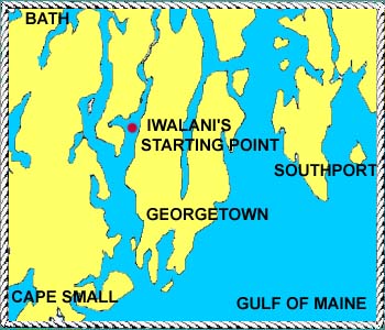
 Georgetown is one of the many islands off the coast of Maine.
Located at about 43 degrees 48 minutes north and 69 degrees 45
minutes west, it lies at the mouth of the Kennebec River. The
island is about ten miles long and three miles wide and covers
18.5 square miles. The climate ranges from hot summers ( temperatures
up to 98 degrees Fahrenheit) to blizzard conditions with temperatures
down to 20 degrees below zero in the winter. The convoluted coastline
of Maine was formed when glaciers scoured the earth while advancing
south. The glaciers also left one of the few sand beaches on the
coast of Maine, now part of Reid State Park. About 900 people
live on the island which has a car bridge to the mainland. The
township of Georgetown was incorporated in 1716, the tenth corporate
town in Maine. The place where Iwalani was built is called Williams
Farm, in West Georgetown. The farm dates back to the 1700's. Georgetown is one of the many islands off the coast of Maine.
Located at about 43 degrees 48 minutes north and 69 degrees 45
minutes west, it lies at the mouth of the Kennebec River. The
island is about ten miles long and three miles wide and covers
18.5 square miles. The climate ranges from hot summers ( temperatures
up to 98 degrees Fahrenheit) to blizzard conditions with temperatures
down to 20 degrees below zero in the winter. The convoluted coastline
of Maine was formed when glaciers scoured the earth while advancing
south. The glaciers also left one of the few sand beaches on the
coast of Maine, now part of Reid State Park. About 900 people
live on the island which has a car bridge to the mainland. The
township of Georgetown was incorporated in 1716, the tenth corporate
town in Maine. The place where Iwalani was built is called Williams
Farm, in West Georgetown. The farm dates back to the 1700's. |